
 |
|
| Rating: 4.8 | Downloads: 1,000,000+ |
| Category: Maps & Navigation | Offer by: TruckersReport.com |
The Hammer: Truck GPS & Maps app provides essential navigation tools for truck drivers. It features detailed maps, routing assistance, and tracking functionalities specifically designed for the trucking industry, ensuring reliable guidance during long hauls. This mobile application caters primarily to professional truck drivers, fleet managers, and logistics professionals needing accurate on-road navigation and trip management solutions.
Hammer: Truck GPS & Maps offers significant value by streamlining complex logistics tasks. Users benefit from time and fuel savings through efficient route planning and real-time tracking, enhancing overall operational efficiency. Its focus on trucking-specific requirements makes it an invaluable practical tool, reducing driver stress and improving route success rates.
App Features
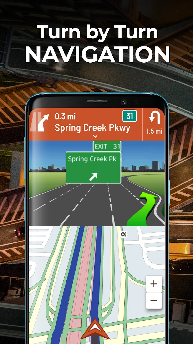
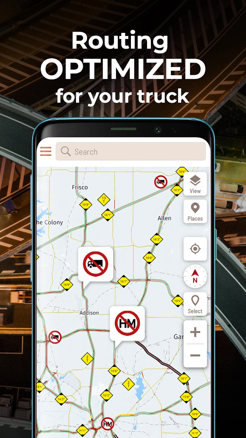
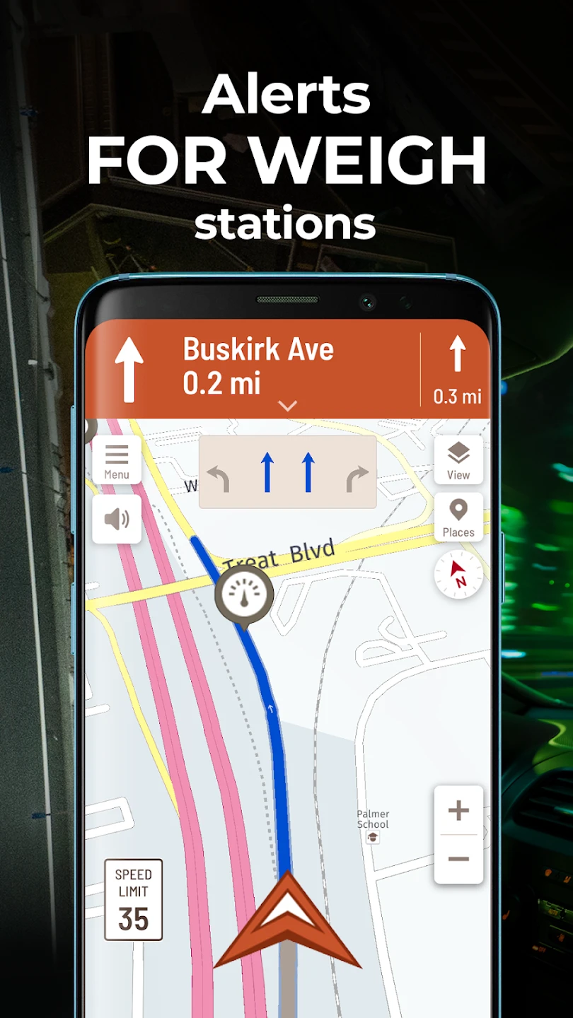
- Detailed Truck-Specific Maps: Navigate challenging terrains and find truck-friendly routes, bypassing obstacles like narrow bridges or low-clearance entrances. This feature ensures safer and smoother journeys by avoiding potential hazards common for large vehicles, reducing travel time and improving safety margins.
- Advanced Routing & ETA Calculation: Benefit from intelligent route planning that prioritizes factors like road type, weight restrictions, and distance, providing a highly accurate estimated time of arrival (ETA). The system dynamically adjusts the route if traffic or unexpected road closures occur, offering significant improvements in navigation reliability and planning efficiency.
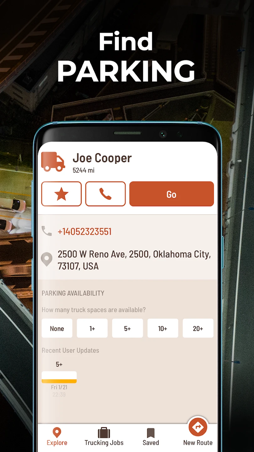
- Live Tracking & Geofencing: Monitor your truck’s real-time location and receive notifications for arrival at waypoints or destinations. Set up custom geofences to be alerted when entering specific zones, such as customer delivery locations, yard boundaries, or designated rest areas, enhancing logistical oversight and timely communication.
- Digital Logbook & Hours-of-SERVICE Tracking: Easily manage your Electronic On-Dashboard (EOD) or Hours-of-Service (HoS) requirements directly within the app. Automatically track driving, resting, and working hours, helping you stay compliant with regulations and avoid violations, simplifying duty time management on the road.
- Offline Maps & GPS Functionality: Download specific map regions or entire country maps for offline use, ensuring you have navigation even in areas with poor signal or no internet connection. The built-in GPS works reliably to pinpoint your truck’s location and guide you to your destination, offering crucial navigation independence in remote or low-connectivity trucking routes.
- Customizable Dashboard & User Profiles: Tailor the app’s interface to display essential information like fuel level, speed, upcoming deliveries, and weather conditions at a glance. Different user profiles can be set up for multiple drivers in a fleet, ensuring each sees relevant data specific to their role and route, boosting personalization and fleet-wide usability.
Pros & Cons
Pros:
- Highly detailed routing tailored for trucks
- Voice-guided navigation for driver focus
- Comprehensive tracking features for managers
- Offline map capability for remote areas
Cons:
- Potential data usage with live tracking
- Initial map download can take significant storage space
- Sometimes requires cellular connection for full map updates
- Interface complexity might take time getting used to
Similar Apps
| App Name | Highlights |
|---|---|
| MapRoute Pro |
This app offers detailed route planning with fuel cost estimations. Known for its customizable route preferences and job scheduling integration. |
| TachoTruck Navigator |
Designed for professional drivers, it includes digital tachograph logging and real-time traffic updates for safer, faster driving. |
| Haulio Fleet |
Offers collaboration tools and fuel price comparisons, ideal for managing multiple trucks or routes across large territories. |
Frequently Asked Questions
Q: What is the best way to download maps in Hammer: Truck GPS & Maps for my frequent routes?
A: For frequent routes, you can download the specific map region corresponding to those routes directly within the app. Go to the ‘Maps’ section, select the country, and then download the relevant regions (e.g., states or provinces). This ensures you have highly detailed navigation data available instantly without needing an active internet connection during your journey.
Q: Can Hammer: Truck GPS & Maps help me plan routes avoiding toll roads?
A: Yes, the advanced routing features in Hammer: Truck GPS & Maps allow you to customize your route preferences. You can often set filters to prioritize routes that minimize or avoid toll roads, saving you money. Check the route planning options within the app for customizable filters and toll avoidance settings before starting your trip.
Q: Is real-time traffic information available in the free version of Hammer: Truck GPS & Maps?
A: Hammer: Truck GPS & Maps typically provides core GPS navigation and tracking features in its basic version. However, features like real-time traffic updates and avoidance might be included in the free version or require a premium subscription, depending on the specific provider’s model. You would need to check the app store listing or in-app information for the most accurate details on the freemium model or subscription requirements.
Q: Can I use Hammer: Truck GPS & Maps to track multiple trucks simultaneously from my phone?
A: While designed primarily for individual use, Hammer: Truck GPS & Maps can display tracking data for multiple trucks if they are all set up to share their location via the app. This depends on the settings configured for each driver and the app’s permissions. Fleet managers might find it useful for tracking a small number of devices, but more complex fleet management often requires dedicated management software beyond the standard app experience.
Q: How does the offline mapping feature work in Hammer: Truck GPS & Maps?
A: You can pre-download map data for specific areas. When you are in a region you previously downloaded, the app will use the cached map data instead of needing an internet connection. This offline data allows the app to provide navigation instructions and display your route, just like online. It works by pre-storing map tiles and routing data before entering the offline area, ensuring you have the necessary navigation information available anywhere along your trip.
Screenshots
 |
 |
 |
 |
Hammer: Truck GPS & Maps App Download |
|
|---|---|